Creating these maps was a challenge. I spent a lot time trying to understand each step in the instructions; this was not easy. I will still have to go back in an attempt to fully understand the concept of projections.
Saturday, January 30, 2010
"GIS is not just about making maps". This map shows an elevation raster image using the stretched symbology. Again, trying to remember various steps from the prior week's lab was a challenge.
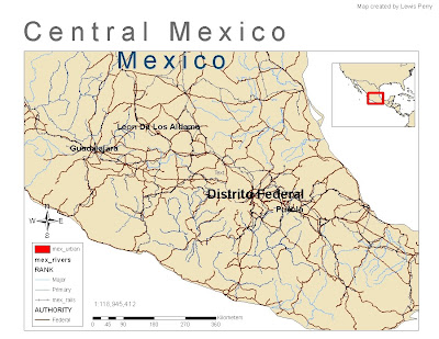
"GIS is not just about making maps". In this map ArcGIS was used to show central Mexico states with a population of over 1 million. An inset map was used to show the location of central Mexico in relation to the surrounding areas. Trying to remember various steps from the prior week's lab was a challenge.
"GIS is not just about making maps". In this map ArcGIS was used to show population density in the Mexico states. The symbology used is graduated colors scheme with 6 classes. Trying to remember various steps from the prior week's lab was a challenge.
I enjoyed this lab. It showed how powerful ArcMap is. I know there is a lot more this software package can do. I did not have any problems with the lab because the step-by-step instructions were clear and easy to understand.
In this exercise I used ArcMap to find a suitable location for a new youth center. This exercise went much smoother than the first one (Planning a Trip to San Diego) due to familiarity with the layout of ArcMap. I am getting more familiar with the toolbar and layout menus. Persistent practicing with ArcMap will be vital in learning GIS.
I enjoyed exploring ArcGIS for the first. ESRI does a good job explaining every step, in addition to showing the snapshots of what your results should look like. Finding the correct tools on the ArcMap tool bar was a challenge. I wouldn't call a pitfall, but instead call it a learning curve.